


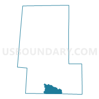
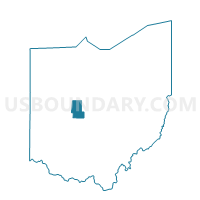
Voting District DARBY 3, Union County, Ohio
About
Outline

Summary
| Unique Area Identifier | 652863 |
| Name | Voting District DARBY 3 |
| County | Union County |
| State | Ohio |
| Area (square miles) | 11.47 |
| Land Area (square miles) | 11.32 |
| Water Area (square miles) | 0.15 |
| % of Land Area | 98.72 |
| % of Water Area | 1.28 |
| Latitude of the Internal Point | 40.12501220 |
| Longtitude of the Internal Point | -83.35566900 |
Maps

Graphs
Select a template below for downloading or customizing gragh for Voting District DARBY 3, Union County, Ohio


Neighbors
Neighoring Voting District (by Name) Neighboring Voting District on the Map
- Voting District DARBY 1, Union County, OH
- Voting District DARBY 2, Union County, OH
- Voting District JEROME 5, Union County, OH
- PRECINCT DARBY, Madison County, OH
- PRECINCT PIKE, Madison County, OH
- Voting District UNION 2, Union County, OH
Top 10 Neighboring County Subdivision (by Population) Neighboring County Subdivision on the Map
- Jerome township, Union County, OH (7,541)
- Darby township, Madison County, OH (4,226)
- Darby township, Union County, OH (2,060)
- Union township, Union County, OH (1,763)
- Pike township, Madison County, OH (580)